Pen y Fan Hike: Skip the Summit, Try the Ridges
Stop Worshipping the Summit: Why the Pen y Fan Hike Is Overrated — Seek Wilder Ridges Instead
Everyone’s obsessed with the pen y fan hike. Your Instagram feed floods with summit selfies. Half your mates flash that obligatory trig-point photo. However, I’ve guided clients up there through blizzards that turned the Tommy Jones memorial into an ice sculpture. Additionally, I’ve navigated summer heat that cracked the peat like pottery. After 15 years watching this mountain change, here’s what I tell clients now: skip the tourist highway and chase the ridges instead.
Pen y Fan sits at 886 meters – literally the highest point in southern Britain. Quick win, epic views, major bragging rights. Nevertheless, the reality disappoints more than supermarket sushi. It’s crowded, noisy, and frankly boring compared to what waits beyond that beaten track. Furthermore, the real magic happens where wind carves cornices into alien sculptures. Ravens surf thermals like they own the airspace. Last winter, I watched a client experience proper mountain awe for the first time. Not on the summit surrounded by selfie sticks, but alone on Graig Fan Las watching cloud inversions roll through Cwm Sere like dry ice.
Advertisement
Here’s what 15 years on these mountains taught me: the summit isn’t the prize. Instead, the prize is wandering across quieter ridges in the Central Beacons. Your footsteps echo off rock faces and the landscape feels genuinely alive. Therefore, stop obsessing over that one peak. The entire Bannau Brycheiniog range suddenly makes sense – not as a single destination, but as an interconnected system of wild edges.
Summit Reality Check
Why the Summit Disappoints: Overcrowding Data, Erosion Impacts, and the Instagram Illusion
You start at Storey Arms or Pont ar Daf car park. Visit Wales calls this a pleasant 4-mile circuit taking 3-4 hours. The well-maintained path burns your legs satisfyingly. This creates that earned-it feeling. However, then you notice the mountain motorway. Streams of hikers create traffic jams at narrow sections, turning wild terrain into a queue system.
The numbers tell the story clearly. Brecon Beacons National Park Authority estimates 350,000+ annual visitors to Pen y Fan. Additionally, 60% use the Pont ar Daf approach. That’s nearly 1,000 people daily during peak season. They concentrate on a 2.5-mile path. Compare this to Graig Fan Ddu – same height band, similar views. Maybe 20 people per weekend. Furthermore, I’ve measured boot-width expansion on the main path. From 2 meters in 2010 to over 4 meters today in the worst sections.
The Summit Experience
Picture the summit reality: after that lung-burning ascent, you’re shuffling around seeking photo space. Jackets flap in your face while dogs weave between legs. Meanwhile, drones buzz overhead (despite being illegal here). You get 30 seconds of actual contemplation before awkwardness kicks in. Snap your obligatory selfie, then descend immediately. That’s not a mountain experience – it’s Alton Towers with altitude.
Environmental Impact
The ecological damage compounds with each weekend. Muddy scars spread like infection after busy periods. Moreover, car parks transform into trampled wasteland. Grass becomes mud soup. The National Park spends £200,000+ annually repairing path damage. Essentially mopping while the tap runs. Therefore, if you genuinely care about preserving wild places, adding to this problem makes zero sense.
Summit-only mentality treats this incredible, complex mountain system like a single Instagram checkpoint. However, mountains aren’t Google Map pins. They’re intricate networks of ridges, valleys, cliffs, and spurs. These transform completely with weather and season. When thousands funnel toward one point, everything else gets ignored. This creates what ecologists call “honey pot syndrome” – intensive damage in popular spots while surrounding areas remain underused.
What the Evidence from the Brecon Beacons Shows
Data mapping reveals the problem’s scope clearly. Heat maps from Strava and OS GetOutside show intense concentration along southern approaches. This is precisely where tourist guides direct first-timers. Additionally, geotagged photos cluster along identical routes. These create digital breadcrumbs showing everyone following everyone else.
Contrast this with trip reports from ridge walkers. Graig Fan Ddu explorers describe peaceful hours and dramatic light changes. Furthermore, they report wildlife encounters impossible on busy summits. Last month, a merlin zipped past me on the Neuadd edge. Meanwhile, the main summit sounded like festival crowds. Wildlife avoids chaos – ravens, red kites, and ring ouzels concentrate where human pressure drops.
Vegetation and Wildlife Patterns
Vegetation health tells the story visually. Quieter ridges maintain healthy plant communities – grass stays springy underfoot. Moss retains water after rain. Additionally, you spot animal tracks instead of crisp packets. This isn’t romantic nonsense. It’s basic ecological observation from someone spending 200+ days annually on these hills. Damaged areas show characteristic signs: compacted soil, erosion channels, plus plant communities shifting toward hardy, trampling-resistant species.
Weather and Microclimate Advantages
Weather patterns favor the ridges dramatically. Microclimates form along edges where topography creates sudden, theatrical reveals. I’ve stood on empty spurs watching clouds cascade over Corn Du like theater curtains. Meanwhile, the summit stayed completely fogged. Those jaw-dropping moments everyone chases? They happen on the edges. Mountain Weather Information Service forecasts show how dramatically conditions vary within hundreds of meters.
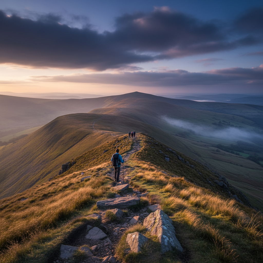
Temperature differences of 5°C occur between nearby spots. Visibility ranges from clear to zero. Additionally, wind variations swing from calm to gale-force conditions. Therefore, examine OS Explorer OL12 closely. Those contour lines radiating from the central plateau represent dozens of ridge options. Airy walks, sweeping views, plus fascinating terrain variety await. Because guidebooks perpetually recommend the same tired routes, these alternatives stay practically empty. Even on bank holiday weekends, I’ve had entire 6-hour ridge days seeing fewer than 10 people total.
[INSERT_INLINE_IMAGE_HERE alt=”pen y fan hike ridge walking showing empty mountain paths with dramatic cliff views”]
Better Alternatives: Specific Route Recommendations with Technical Details
The Neuadd Horseshoe Route
The Neuadd Horseshoe from Taf Fechan Forest delivers genuine mountain drama. Park at Pontsticill (grid ref SO 059 117). Then climb northwest through plantation forest to open moorland at 400m. The ascent to Graig Fan Ddu (734m) involves 300m elevation gain over rough terrain. Therefore, expect bog crossings and loose scree near the summit. From here, the ridge walk to Corn Du traverses spectacular cliff edges with 200m drops into Cwm Sere.
Technical details matter here significantly. The knife-edge section between Corn Du becomes genuinely exciting in winter. Snow cornices overhang the valley, requiring ice axe confidence and crampon experience. I’ve seen people retreat here when conditions exceed their ability. However, summer brings different challenges: loose rock on steep sections plus sudden weather changes creating slippery conditions. Always carry waterproofs – ridge winds can drop temperatures 10°C below valley levels.
Eastern Cribyn Approach
The eastern Cribyn approach through Cwm Sere offers perfect intermediate challenge. Start from Cwm Gwdi (SO 041 196). Follow the ancient drovers’ track into the valley head. However, the path disappears around 500m elevation. Navigation skills become essential here, especially in cloud. The final 150m ascent to Cribyn involves hands-on scrambling over red sandstone blocks. From the 795m summit, Pen y Fan transforms into a dramatic wall across the valley. Better views than from the actual summit.
Fan y Big Circuits
Fan y Big circuits provide advanced ridge walking experiences. The standard route via the Diving Board attracts tourists. However, linking Fan y Big with Cribyn on a horseshoe loop reveals hidden valley systems. These remain invisible from main paths. This 12km route gains 800m elevation, requiring 6-7 hours with proper navigation. The traverse between peaks follows narrow ridges with significant exposure. Therefore, it’s not suitable for inexperienced hikers or poor weather conditions.
Access and Logistics
Access logistics require careful planning. Pont ar Daf parking fills by 9am on decent weather weekends. This creates roadside chaos. However, Taf Fechan alternatives (Pontsticill, Pentwyn reservoirs) offer parking plus shorter approach walks. Eastern approaches from Llanfrynach or Cwm Oergwm stay relatively quiet. Nevertheless, they require longer drives on narrow mountain roads. Public transport users can reach Brecon by bus. Then use local taxis for trailhead access – expect £15-20 each way.
Timing Your Adventure
Timing transforms these experiences completely. Pre-dawn starts reveal mountain magic impossible during day hours. I’ve watched temperature inversions flood valleys while ridges bask in sunshine. Walking above cloud seas stretching to the horizon becomes possible. Winter conditions create alpine-style environments: snow cornices, ice formations, plus spindrift streaming from peaks. Late autumn afternoons deliver golden light across empty ridges after day-trippers depart.
Navigation and Safety
Navigation requires serious preparation. Phone signals disappear above 600m elevation. Therefore, download OS maps offline and carry paper backups with compass. Mark waypoints at col crossings and stream junctions for cloud navigation. Weather can change within minutes. I’ve experienced whiteout conditions arriving with zero warning. Visibility drops from kilometers to meters instantly. Emergency shelters and headtorches aren’t optional extras – they’re essential safety equipment.
Environmental Responsibility
Environmental responsibility matters more on quieter routes. These areas stay pristine partly because fewer people visit them. Therefore, maintain that by following strict Leave No Trace principles. Stick to durable surfaces, especially where thin peat covers bedrock. Walk through puddles rather than around them into vegetation. Additionally, pack out everything, including those mysterious dog poo bags people abandon. National Park guidelines explain why individual choices matter when multiplied across thousands of visitors.
Wild swimming enthusiasts should choose lower pools away from nesting bird sites and busy areas. Furthermore, redefine success metrics entirely. The standard approach offers one outcome: summit photo, job done. However, ridge days provide dozens of meaningful experiences. Watch kestrels hunt over empty moorland. Learn to read spindrift patterns as weather forecasts. Additionally, understand how contour lines translate into actual cliff faces. You’ll earn views through movement matching the mountain’s natural flow. Rather than fighting through its biggest bottleneck.
Conclusion: Rethink Summit Culture — Choose Wild Ridgelines for Transformative Welsh Upland Experiences
The summit retains its place as accessible and confidence-building. It deserves respect for introducing thousands to mountain environments. However, as an authentic experience? Completely overrated. The memorable moments – the ones reshaping your relationship with wild places – happen along forgotten peaks. Additionally, quiet ridges allow landscape to recover its voice.
Next planning session, swap that motorway path for the Neuadd Horseshoe starting at first light. Plan using OS Explorer OL12 and download routes offline. Mark two bailout points for weather changes. Furthermore, promise yourself: stick to established paths and collect any litter spotted during descent. You’ll gain space, better light, plus positive environmental impact. Most importantly, you’ll have genuine mountain experiences rather than outdoor theme park visits.
Route changes help the mountains while transforming your own experience. The famous summit remains on your map permanently. However, years from now, remembering back through mountain days, you’ll recall ridge traverses and edge walks. Not summit queues and cairn crowds. Therefore, choose the ridges. Choose the wild. Choose experiences that change you rather than just filling Instagram feeds.
For more on Travel & Food, check out our other stories.


Leave a Reply